Written by Atlas Editorial · Last updated
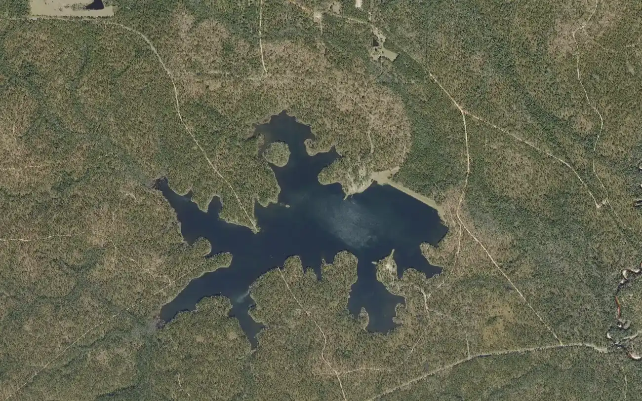
Hurricane Lake is a 318-acre state fishing lake in Blackwater River State Forest, northwest of Baker, Florida. Gas motors are prohibited. Two campgrounds each have a concrete ramp, and fish attractors are marked with buoys.
Hurricane Lake today
Measured readings, not a bite prediction. Where each number comes from · All Alabama lakes today
- Acreage
- 318 acres
- Max Depth
- 25 feet (7 feet on average)
- Length
- N/A (not published by the state)
- Shoreline
- N/A (not published by the state)
- Impounded
- Man-made impoundment built in 1971
- River System
- Fish Management Area; campgrounds run by the Florida Forest Service
- Access
- Public — concrete ramps with courtesy docks in the north and south campgrounds, a pier, and bank-fishing fingers
The Water
Hurricane Lake map: hotspots, ramps and more
Numbers = fishing hotspots · R = boat ramp · C = campground · P = fishing pier · B = bait shop · M = marina. Tap a pin.
Hurricane Lake is a 318-acre impoundment in Blackwater River State Forest, about 12 miles northwest of Baker in Okaloosa County. It averages 7 feet deep and reaches 25, and the state has stocked it with largemouth bass, bluegill, redear sunfish and channel catfish. It was built in 1971 and opened to fishing in 1973. The deepest water is near the dam and along the old streambed, and a considerable amount of flooded timber remains as fish cover. Concrete ramps with courtesy docks are in both the north and south campgrounds, reached from Beaver Creek Road north of State Road 4, and the state inventory lists a launch fee at each. Anglers have logged 2 bass of eight pounds or more from the lake in the state's TrophyCatch program. Nobody publishes a regular dated catch report we can cite, so the spots on this page are access points, not promises.
“Hurricane Lake holds fish in patterns you can set your watch to. The bite isn't a secret — it's what most fishermen don't know about where the grass thins onto a hard ledge.”
Alabama Fishing Atlas Editorial
Today's Conditions
Major and minor solunar windows shift daily with the moon’s transit. Fish the windows above, or check the Seasonal Playbook below for Hurricane Lake’s current pattern.
Seasonal Playbook
Florida's wildlife agency gives no spring pattern for Hurricane Lake, and no dated spring report is published that we can cite, so this section keeps to what its page supports. Hurricane Lake is a 318-acre impoundment in Blackwater River State Forest, about 12 miles northwest of Baker in Okaloosa County. It averages 7 feet deep and reaches 25, and the state has stocked it with largemouth bass, bluegill, redear sunfish and channel catfish. Bluegill and redear sunfish leave their gravel beds for deeper water late in the year; fish near the bottom with crickets or wigglers on 4 to 6 pound line, small hooks and split shot two to three feet up. Concrete ramps with courtesy docks are in both the north and south campgrounds, reached from Beaver Creek Road north of State Road 4, and the state inventory lists a launch fee at each.
No dated summer report is published for Hurricane Lake that we can cite, and the agency's written forecast does not cover the hot months. The north campground has a wheelchair-accessible fishing pier and sites with electric and water hookups; the south campground is primitive, with earthen fishing fingers built for bank anglers. Channel catfish take night crawlers or beef or chicken liver on the bottom in deeper water. Concrete ramps with courtesy docks are in both the north and south campgrounds, reached from Beaver Creek Road north of State Road 4, and the state inventory lists a launch fee at each. Gasoline motors are prohibited and electric trolling motors are allowed. The lake is a Fish Management Area, so its limits are the ones printed for such areas in Florida's freshwater regulations. The deepest water is near the dam and along the old streambed, and a considerable amount of flooded timber remains as fish cover.
The agency's forecast for Hurricane Lake is written for the cooling months. For the year's biggest bass the agency points to deep water along the earthen dam, around standing timber, and near the fish attractors marked with orange and white buoys. As the water cools it says to fish midday in the warmest water you can find, with sunfish or shad imitations, suspending crankbaits, Rat-L-Traps or slow spinnerbaits. Channel catfish take night crawlers or beef or chicken liver on the bottom in deeper water. No dated fall report is published for the lake that we can cite, so this is standing advice and not this season's catch. Gasoline motors are prohibited and electric trolling motors are allowed. The lake is a Fish Management Area, so its limits are the ones printed for such areas in Florida's freshwater regulations.
Cold weather is what the agency's Hurricane Lake forecast is about. For the year's biggest bass the agency points to deep water along the earthen dam, around standing timber, and near the fish attractors marked with orange and white buoys. As the water cools it says to fish midday in the warmest water you can find, with sunfish or shad imitations, suspending crankbaits, Rat-L-Traps or slow spinnerbaits. Bluegill and redear sunfish leave their gravel beds for deeper water late in the year; fish near the bottom with crickets or wigglers on 4 to 6 pound line, small hooks and split shot two to three feet up. The north campground has a wheelchair-accessible fishing pier and sites with electric and water hookups; the south campground is primitive, with earthen fishing fingers built for bank anglers. Concrete ramps with courtesy docks are in both the north and south campgrounds, reached from Beaver Creek Road north of State Road 4, and the state inventory lists a launch fee at each.
Species on this water
Largemouth Bass
Year's biggest bass in the cool months: deep water along the dam, standing timber, and the buoyed fish attractors, fished midday.
- Creel limit
- 5/day (combined)
- Best season
- Spring
- State record
- 16 lbs 8 oz
Bluegill
Deeper water late in the year; crickets or wigglers near the bottom on light line.
- Creel limit
- No statewide limit
- Best season
- Spring/Summer
Catfish
Channel catfish on the bottom in deeper water with night crawlers or liver.
- Creel limit
- No statewide limit
- Best season
- Summer/Winter
Fishing Guides
Stay & Eat
On the Water
Boat ramps
Hurricane Lake North Recreation Area
Baker, FL
- Parking
- spots
- Fee
- Launch fee (Florida Forest Service)
Concrete ramp with courtesy dock and an accessible pier. Electric motors only.
DirectionsHurricane Lake South Recreation Area
Baker, FL
- Parking
- spots
- Fee
- Launch fee (Florida Forest Service)
Concrete ramp with courtesy dock in the primitive campground. Electric motors only.
Directions➤ Map of all 2 boat ramps on Hurricane Lake
Bait shops near the lake
Regulations
Regulations on Hurricane Lake
- Bass (combined)
- No published number on the state's page for this lake; the Fish Management Area limits in Florida's freshwater regulations apply. · No published length on the state's page for this lake; Fish Management Area rules apply.
- Crappie
- No published number on the state's page for this lake; Fish Management Area rules apply. · No published length on the state's page for this lake; Fish Management Area rules apply.
- Striped/White Bass
Gasoline boat motors are prohibited; electric trolling motors are allowed. The lake is a Fish Management Area.
A Florida freshwater fishing license. The whole water is in Florida, in Okaloosa County.. Always verify current rules before your trip.
Full Alabama fishing regulations ›Nearby Waters
Hurricane Lake questions
Fishing regulations, water conditions, and seasonal patterns change. Alabama Fishing Atlas provides informational content only. Verify all regulations with the Alabama Department of Conservation and Natural Resources before fishing, keeping any fish, or launching watercraft. We are not liable for decisions made based on information published here. Full disclaimer →
Data sources
- Florida Fish and Wildlife Conservation Commission, Hurricane Lake — https://myfwc.com/fishing/freshwater/sites-forecasts/nw/hurricane-lake/ (size, depth, stocking, campgrounds, rules, cool-season forecast; checked 2026-11-12)
- Florida Fish and Wildlife Conservation Commission, Florida Boat Ramp Inventory — https://gis.myfwc.com (ramp names, positions, lanes, fees, managers; retrieved 2026-11-12)
- Florida Fish and Wildlife Conservation Commission, Northwest Region Fishing Forecasts — https://myfwc.com/fishing/freshwater/sites-forecasts/nw/ (list of state-managed fishing sites in the region; checked 2026-11-12)
- OpenStreetMap contributors — https://www.openstreetmap.org (dam, pier and launch positions; read 2026-11-12)
Data last reviewed: 2026-11-12