Written by Atlas Editorial · Last updated
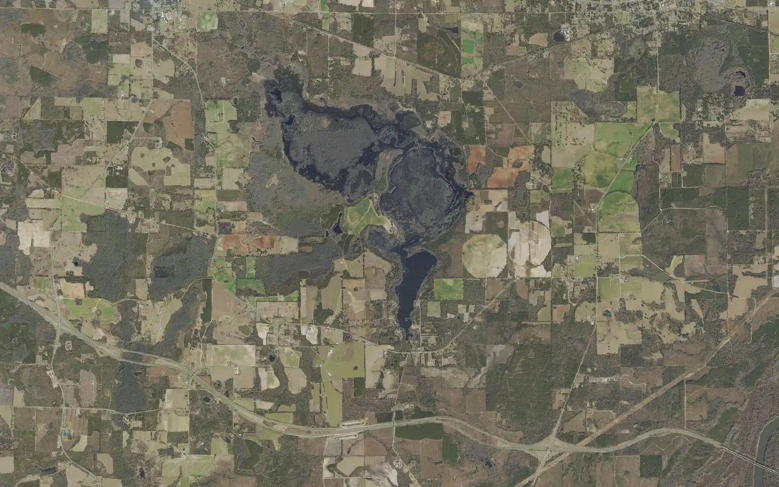
Ocheesee Pond is a 2,225-acre cypress lake near Grand Ridge, Florida, with dark tannic water. The state rates it for bluegill, shellcracker, bass and late-fall crappie. Stumps are everywhere, so run slowly.
Ocheesee Pond today
Measured readings, not a bite prediction. Where each number comes from · All Alabama lakes today
- Acreage
- 2,225 acres
- Max Depth
- N/A (not published by the state)
- Length
- N/A (not published by the state)
- Shoreline
- N/A (not published by the state)
- Impounded
- A natural cypress pond; no dam is described by the state
- River System
- Public water; ramp run by Jackson County
- Access
- Public — one Jackson County ramp off Shady Grove Road
The Water
Ocheesee Pond map: hotspots, ramps and more
Numbers = fishing hotspots · R = boat ramp · C = campground · P = fishing pier · B = bait shop · M = marina. Tap a pin.
Ocheesee Pond is a 2,225-acre lake south of US 90 at Grand Ridge and Sneads in Jackson County, Florida. Its water is dark and tannic, and the state's wildlife agency says about 90 percent of the surface is covered by cypress trees. Chain pickerel are on the agency's species list for the pond as well. The public ramp is a one-lane Jackson County landing off Shady Grove Road: State Road 69 south from Grand Ridge for a mile, then left on County Road 69A for 5.9 miles. Anglers have logged 4 bass of eight pounds or more from the lake in the state's TrophyCatch program. Nobody publishes a regular dated catch report we can cite, so the spots on this page are access points, not promises. No fish camps are named on the state's page; its fisheries biologists at the regional office take questions at 850-265-3676.
“Ocheesee Pond holds fish in patterns you can set your watch to. The bite isn't a secret — it's what most fishermen don't know about where the grass thins onto a hard ledge.”
Alabama Fishing Atlas Editorial
Today's Conditions
Major and minor solunar windows shift daily with the moon’s transit. Fish the windows above, or check the Seasonal Playbook below for Ocheesee Pond’s current pattern.
Seasonal Playbook
Florida's wildlife agency gives no spring pattern for Ocheesee Pond, and no dated spring report is published that we can cite, so this section keeps to what its page supports. Ocheesee Pond is a 2,225-acre lake south of US 90 at Grand Ridge and Sneads in Jackson County, Florida. Its water is dark and tannic, and the state's wildlife agency says about 90 percent of the surface is covered by cypress trees. For bluegill, fish three to five feet of water or the deep holes in the main section with grass shrimp, crickets, wigglers, or 1/16 to 1/8 ounce beetle spins; redear sunfish are in the same places and take worms. The public ramp is a one-lane Jackson County landing off Shady Grove Road: State Road 69 south from Grand Ridge for a mile, then left on County Road 69A for 5.9 miles. Bass follow Florida's statewide rule of five a day, only one of them 16 inches or longer.
No dated summer report is published for Ocheesee Pond that we can cite, and the agency's written forecast does not cover the hot months. No fish camps are named on the state's page; its fisheries biologists at the regional office take questions at 850-265-3676. Stumps and snags are everywhere. The agency says they draw some of the biggest bluegill and are also a hazard for boaters who do not know the pond, so run slowly. For bluegill, fish three to five feet of water or the deep holes in the main section with grass shrimp, crickets, wigglers, or 1/16 to 1/8 ounce beetle spins; redear sunfish are in the same places and take worms. The public ramp is a one-lane Jackson County landing off Shady Grove Road: State Road 69 south from Grand Ridge for a mile, then left on County Road 69A for 5.9 miles. Bass follow Florida's statewide rule of five a day, only one of them 16 inches or longer.
The agency's forecast for Ocheesee Pond is written for the cooling months. Bass fishing should be fair through the fall, the agency says: fish early morning and late afternoon along weed lines and cypress trees with spinnerbaits, crankbaits, dark plastic worms or live shiners. The pond also holds some decent-sized black crappie, which the agency expects to pick up in late fall. Stumps and snags are everywhere. The agency says they draw some of the biggest bluegill and are also a hazard for boaters who do not know the pond, so run slowly. No dated fall report is published for the lake that we can cite, so this is standing advice and not this season's catch. Bass follow Florida's statewide rule of five a day, only one of them 16 inches or longer. Anglers have logged 4 bass of eight pounds or more from the lake in the state's TrophyCatch program.
Cold weather is what the agency's Ocheesee Pond forecast is about. Bass fishing should be fair through the fall, the agency says: fish early morning and late afternoon along weed lines and cypress trees with spinnerbaits, crankbaits, dark plastic worms or live shiners. For bluegill, fish three to five feet of water or the deep holes in the main section with grass shrimp, crickets, wigglers, or 1/16 to 1/8 ounce beetle spins; redear sunfish are in the same places and take worms. The pond also holds some decent-sized black crappie, which the agency expects to pick up in late fall. The public ramp is a one-lane Jackson County landing off Shady Grove Road: State Road 69 south from Grand Ridge for a mile, then left on County Road 69A for 5.9 miles. Anglers have logged 4 bass of eight pounds or more from the lake in the state's TrophyCatch program.
Species on this water
Largemouth Bass
Fair through the fall: early and late along weed lines and cypress trees with spinnerbaits, crankbaits, dark worms or shiners.
- Creel limit
- 5/day (combined)
- Best season
- Spring
- State record
- 16 lbs 8 oz
Bluegill
3 to 5 feet or the deep holes with grass shrimp, crickets, wigglers or small beetle spins; shellcracker on worms.
- Creel limit
- No statewide limit
- Best season
- Spring/Summer
Crappie
Some decent-sized black crappie; the state expects them to pick up in late fall.
- Creel limit
- 30/day, 9-inch min
- Best season
- Spring/Winter
Fishing Guides
Stay & Eat
On the Water
Boat ramps
Ocheesee Pond Public Boat Ramp
Grand Ridge, FL
- Parking
- spots
- Fee
Jackson County ramp off Shady Grove Road, one launch lane, no launch fee listed.
Directions➤ Map of all 1 boat ramps on Ocheesee Pond
Bait shops near the lake
Regulations
Regulations on Ocheesee Pond
- Bass (combined)
- 5 black bass per day under Florida's statewide rule. · No statewide minimum length for largemouth bass; only 1 of the 5 may be 16 inches or longer.
- Crappie
- No minimum or special daily number for crappie is given on the state's Ocheesee Pond page; Florida's statewide freshwater bag limit applies. · No minimum length for crappie is given on the state's Ocheesee Pond page.
- Striped/White Bass
No special rules are listed for this water on the state's page. Bass follow the statewide rule: 5 a day, only 1 of them 16 inches or longer.
A Florida freshwater fishing license. The whole water is in Florida, in Jackson County.. Always verify current rules before your trip.
Full Alabama fishing regulations ›Nearby Waters
Ocheesee Pond questions
Fishing regulations, water conditions, and seasonal patterns change. Alabama Fishing Atlas provides informational content only. Verify all regulations with the Alabama Department of Conservation and Natural Resources before fishing, keeping any fish, or launching watercraft. We are not liable for decisions made based on information published here. Full disclaimer →
Data sources
- Florida Fish and Wildlife Conservation Commission, Ocheesee Pond — https://myfwc.com/fishing/freshwater/sites-forecasts/nw/ocheesee-pond/ (size, cypress cover, access directions, fall forecast; checked 2026-11-12)
- Florida Fish and Wildlife Conservation Commission, Florida Boat Ramp Inventory — https://gis.myfwc.com (ramp names, positions, lanes, fees, managers; retrieved 2026-11-12)
- Florida Fish and Wildlife Conservation Commission, Northwest Region Fishing Forecasts — https://myfwc.com/fishing/freshwater/sites-forecasts/nw/ (list of state-managed fishing sites in the region; checked 2026-11-12)
Data last reviewed: 2026-11-12