AlabamaFishing Atlas
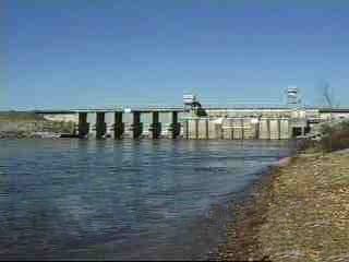
Neely Henry Dam and Powerhouse on the Coosa River near Ohatchee, Alabama

Neely Henry Lake Boat Ramps: Map and Directions

6 public boat ramps on Neely Henry Lake. Tap a pin or a Directions button and your phone’s map takes you to the ramp.

Photo: Mike Cline (via Wikimedia Commons) · Public Domain (released by author Mike Cline, Wikimedia Commons)
Boat ramps on Neely Henry Lake
Tap a pin for the ramp name and directions.
Ramp locations: Google Maps listings. Map tiles © OpenFreeMap / OpenStreetMap contributors.

Every ramp, with directions

Coosa Landing Boat Launch

Gadsden, Alabama · 34.01048, -85.99658

★ 4.7 from 450 Google reviews

➤ Directions

Canoe Creek Boat Launch

Ashville, Alabama · 33.86387, -86.10685

★ 4.7 from 91 Google reviews

➤ Directions

Rainbow Landing

Rainbow City, Alabama · 33.94330, -86.02855

★ 4.5 from 87 Google reviews

➤ Directions

Gadsden City Boat Ramp

Gadsden, Alabama · 34.01018, -85.99653

★ 4.5 from 26 Google reviews

➤ Directions

Tillison’s Bend Boat Ramp

Gadsden, Alabama · 34.01631, -85.93406

★ 4.5 from 22 Google reviews

➤ Directions

Shoal Creek Boat Launch

Ashville, Alabama · 33.81894, -86.06564

★ 3.7 from 3 Google reviews

➤ Directions

Ramp names, locations and ratings come from Google Maps listings, checked 2026-11-11. Fees, hours and water-level closures are not listed there, so check with the ramp owner before you tow.

Ramps with Atlas launch notes

Gadsden City Boat Docks · GadsdenCoosa Landing · GadsdenCanoe Creek Access · OhatcheeGreensport Landing · OhatcheeRainbow Landing · Rainbow CityNeely Henry Dam Tailrace Access · Ohatchee

More for a day on Neely Henry Lake

Neely Henry Lake fishing guide →Bait shops in AshvilleBait shops in GadsdenBait shops in RaglandGreensport Marina and General StoreLakeshore MarinaLittle Bridge Marina LLCAll Alabama boat ramps