Upper Bear Creek Reservoir: Clear-Water Smallmouth and the Headwaters of the Bear Creek Floatway
A 14-mile TVA flood-control reservoir in the hills of Franklin, Winston, and Marion counties — clean Appalachian-plateau water, smallmouth and largemouth to double-digits, and the put-in for one of Alabama's best paddle trips.
Upper Bear Creek Reservoir is a TVA flood-control impoundment on Bear Creek at the Franklin–Winston–Marion county corner in northwest Alabama — closed by Upper Bear Creek Dam in 1978, 14 miles long, clear water, and a rare Alabama smallmouth-bass fishery.
N/A (published by TVA as a narrow, 14-mile headwater reservoir in the Bear Creek system)
Max Depth
N/A
Length
14 miles
Shoreline
N/A
Impounded
1978 (TVA Bear Creek Project)
River System
Bear Creek (Tennessee River tributary)
Access
Public (BCDA permit required ages 16-65)
01 · Overview
The Water
Upper Bear Creek doesn't fish like the big TVA mainstem reservoirs downstream. It's a tributary flood-control pool at the Franklin–Winston–Marion county corner, closed by TVA in 1978 as one of four dams in the Bear Creek Project — 85 feet high, no hydro plant. The pool runs 14 miles through hardwood ridges and rocky shorelines, and the water stays clear most of the year. That clarity plus rocky structure is why Upper Bear produces a real smallmouth fishery — the Bear Creek Lakes together have coughed up smallmouth over five pounds and largemouth over fifteen per BCDA. Three BCDA ramps anchor access: Mon-Dye in Franklin County near Phil Campbell, Quarter Creek in Winston County near Haleyville, and Twin Forks on the upper end near Haleyville. Anglers 16 through 65 need a BCDA user's permit. Memorial Day through Labor Day, TVA runs scheduled releases from 6 a.m. Saturday through 4 p.m. Sunday to feed the 26-mile Bear Creek Floatway below the dam.
“Upper Bear Creek Reservoir holds fish in patterns you can set your watch to. The bite isn't a secret — it's what most fishermen don't know about where the grass thins onto a hard ledge.”
Alabama Fishing Atlas Editorial
02 · Bite Windows
Solunar Forecast
Major and minor solunar windows shift daily with the moon’s transit. Fish the windows above, or check the Seasonal Playbook below for Upper Bear Creek Reservoir’s current pattern.
03 · The Calendar
Seasonal Playbook
March through May is the best open window on Upper Bear. Water climbs from the low 50s into the 70s and largemouth, smallmouth, and spotted bass stage on rocky main-lake points before pulling into the spawning pockets up Quarter Creek, Mon-Dye, and the Twin Forks end. A suspending jerkbait on long pauses catches staging fish on the clear-water points in 6-12 feet; by April a wacky Senko or a Texas-rigged lizard covers the spawning flats. Smallmouth pre-spawn on chunk rock near the dam and the mid-lake points — a 3/8-oz shaky head with a green-pumpkin finesse worm is the go-to. Crappie pull into the back of the creek arms and hang on timber in 6-10 feet; a 1/16-oz jig tipped with a minnow catches fish all day. Channel catfish turn on by late April when surface temps cross 65°F.
June through August the lake sets up on rock and shade. Smallmouth and spotted bass key on main-lake rocky points and the dam-face bluff in 12-25 feet — a drop-shot with a 4-inch finesse worm, a small tube on a 1/4-oz head, a Ned rig on the chunk rock. Largemouth hold shallower on shaded banks in the backs of Quarter Creek and the Mon-Dye embayment; a green-pumpkin jig flipped to laydowns, a frog on the lily pads, a buzzbait at dawn. Topwater schooling fires on the main channel at first light when shad ball up on points. Channel catfish on cut bait and chicken liver hold the mouths of the creek arms. Crappie push to deep brush in 15-20 feet. Remember: scheduled floatway releases run from Upper Bear Dam every Saturday 6 AM through Sunday 4 PM Memorial Day through Labor Day, and that draw can shift the thermocline and move bait — watch the TVA Lakes Info app before a long run.
September through November shad migrate into the creek arms and every species follows the bait. Largemouth and spotted bass chase shad on seawalls, creek-mouth rock, and secondary points up Quarter Creek and Mon-Dye — a lipless crankbait, a shad-color ChatterBait on the points, a walking bait on calm mornings over the flats. Smallmouth slide deeper on main-lake rock ledges as surface temps drop through the 60s — a drop-shot worked vertical on a point in 20-30 feet, a small swimbait parallel to the dam face, a tube on chunk-rock transitions. Crappie reload on brush and timber in 10-15 feet; long-line small jigs to cover water, then vertical jig schools once you mark them. Channel catfish stay reliable on cut bait along the main channel. By mid-November the topwater window closes and the bite slides deeper — suspending jerkbaits and finesse baits on the main-lake rock become the late-fall answer when surface temps drop into the low 50s.
December through February Upper Bear becomes a vertical fishery. Surface temps drop into the 40s and smallmouth and spotted bass stack on the deepest rock — the dam face, main-channel bluffs, and the rock ledges off Mon-Dye. A suspending jerkbait on long pauses catches the sunny-afternoon feeders above 48°F; a hair jig or a blade bait fished vertical works the bluff walls and rock piles on cold-front days. Largemouth pull into the back of the creek arms on warming days when a two-to-three-degree surface bump fires up the shallows — a slow-rolled spinnerbait, a jig-and-pig on wood. Crappie hold deep on brush in 20-25 feet; vertical minnows and tiny jigs catch them. TVA schedules are minimal in winter with the floatway closed — check current elevations on the TVA site before trips since the reservoir can fluctuate several feet through the cold-weather drawdown.
Privately owned 85-acre nature conservatory in Phil Campbell, designated a National Natural Landmark in 1975 by the National Park Service. Home of the Dismalites (bioluminescent fly larvae) — night tours Friday and Saturday in season. A 20-minute drive from Mon-Dye Ramp and a worthwhile half-day stop on any Upper Bear trip.
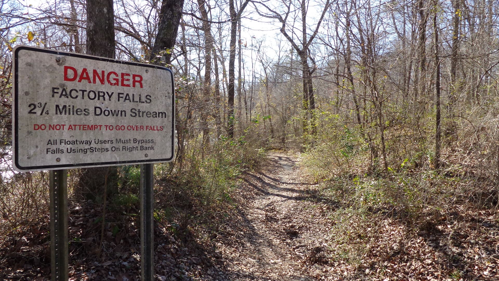
26-mile Class I canoe and kayak run beginning below Upper Bear Creek Dam and ending at Bear Creek Reservoir. TVA-operated recreational releases run Saturday 6 AM through Sunday 4 PM Memorial Day through Labor Day. Upper Factory Falls (Class IV) and Lower Factory Falls (Class VI) are mandatory-portage hazards.
Around Upper Bear Creek Reservoir
Upper Bear Creek Reservoir sits between Phil Campbell on the Franklin County side and Haleyville on the Winston County side — both small-town anchors with gas, ice, and diner-style food ten to twenty minutes from the ramps. Phil Campbell is the closer town to Mon-Dye Ramp; Haleyville is closest to Quarter Creek and Twin Forks. There are no lakeside restaurants or marinas on Upper Bear — this is a quiet, flood-control-first pool where the recreation footprint is ramps, campgrounds (located on the sister reservoirs downstream), and the Bear Creek Floatway below the dam. Dismals Canyon, a National Natural Landmark 20 minutes south in Phil Campbell, is the standout off-water stop — worth a half-day for the bioluminescent Dismalites and the canyon-floor trail. Russellville anchors Franklin County to the north with more restaurants and motel rooms, and the three sister Bear Creek lakes (Little Bear, Big Bear, Cedar Creek) with their five BCDA campgrounds sit within a 15-to-30-minute drive if you need a campsite or a cabin rental.
07 · Launch Day
On the Water
Boat ramps
concrete rampOpen
Quarter Creek Boat Ramp and Beach
Haleyville
Parking
spots
Fee
BCDA user's permit (ages 16-65)
6915 Dime Rd, Haleyville, AL 35565 (Winston County). Bear Creek Development Authority ramp on Upper Bear Creek Reservoir with a public beach and handicap-accessible fishing pier.
144 Mon Dye Rd, Phil Campbell, AL 35581 (Franklin County). BCDA ramp on Upper Bear Creek Reservoir with a public beach and handicap-accessible fishing pier.
10 black bass daily aggregate (largemouth / smallmouth / spotted / Alabama) — Alabama statewide limit. No more than 5 of the 10 may be smallmouth. · No statewide minimum length on largemouth, smallmouth, or spotted bass in Alabama general public waters — Upper Bear Creek Reservoir has no published special black-bass size regulation. Verify current ADCNR regulations before keeping fish.
Crappie
30 per day (statewide). · 9-inch minimum (statewide).
Striped/White Bass
Upper Bear Creek Reservoir is part of the TVA Bear Creek Project, managed for recreation by the Bear Creek Development Authority (BCDA). Anglers ages 16-65 must purchase a BCDA user's permit in addition to an Alabama fishing license. Upper Bear Creek Dam is operated by TVA for flood control and water supply — it is not a hydroelectric facility. Memorial Day through Labor Day, TVA runs scheduled recreational releases from the dam each Saturday 6 AM through Sunday 4 PM to supply flow to the Bear Creek Floatway downstream. Verify current ADCNR regulations at outdooralabama.com and current TVA operating conditions at tva.com/environment/lake-levels/upper-bear-creek before your trip.
Alabama fishing license required for all anglers 16 and older (residents and non-residents). In addition, the Bear Creek Development Authority requires a user's permit for every person ages 16-65 using BCDA lakes and facilities.. Always verify current rules before your trip.
The Tennessee Valley Authority (TVA) owns and operates Upper Bear Creek Dam and the reservoir, completed in 1978 as one of four dams in the Bear Creek Project. Recreation on the reservoir — campgrounds, boat ramps, beaches, and user permits — is managed by the Bear Creek Development Authority (BCDA), a regional authority that operates the Bear Creek Lakes system. Upper Bear is a flood-control and water-supply dam — no hydro plant, no power generation.
A rare Alabama smallmouth-bass fishery and a clear-water reservoir character you don't get on the big TVA mainstem lakes. The 14-mile pool sits on Appalachian-plateau geology with rocky banks and clean water — BCDA reports the Bear Creek lakes system has produced smallmouth over 5 pounds and largemouth over 15 pounds. It's also the put-in for the Bear Creek Floatway below the dam, considered one of the best paddle trips in Alabama.
The pool and dam sit at the corner of Franklin, Winston, and Marion counties in northwest Alabama — Mon-Dye Ramp is in Franklin near Phil Campbell, Quarter Creek and Twin Forks ramps are in Winston near Haleyville, and Upper Bear Creek Dam itself sits in Marion County at roughly 34.273, -87.691.
Yes — you need both an Alabama fishing license (anyone 16 or older, any residency) and a Bear Creek Development Authority user's permit for anyone ages 16 through 65 using BCDA lakes and facilities. The Alabama license is available from ADCNR at Outdoor Alabama online, and the BCDA permit can be purchased through Bear Creek Lakes online.
Memorial Day weekend through Labor Day, TVA runs scheduled recreational releases from Upper Bear Creek Dam each Saturday from 6 AM Central through 4 PM Sunday, feeding the 26-mile Class I floatway down to Bear Creek Reservoir. Upper Factory Falls at Class IV and Lower Factory Falls at Class VI are mandatory-portage hazards on the floatway and should not be attempted. Check current flow on the TVA Lakes Info app or at TVA's lake levels page before launching.
Fishing regulations, water conditions, and seasonal patterns change. Alabama Fishing Atlas provides informational content only. Verify all regulations with the Alabama Department of Conservation and Natural Resources before fishing, keeping any fish, or launching watercraft. We are not liable for decisions made based on information published here. Full disclaimer →
Citation
Data sources
—Tennessee Valley Authority — Upper Bear Creek dam overview (https://www.tva.com/energy/our-power-system/hydroelectric/Upper-Bear-Creek)
—Tennessee Valley Authority — Upper Bear Creek lake levels and operating information (https://www.tva.com/environment/lake-levels/upper-bear-creek)
—Bear Creek Development Authority — Bear Creek Lakes homepage (https://www.bearcreeklakes.com/)
—Bear Creek Development Authority — Boat Ramps (Quarter Creek, Mon-Dye, Twin Forks) (https://bearcreeklakes.com/boat-ramps/)
—Bear Creek Development Authority — Floatway (https://bearcreeklakes.com/floatway/)
—Wikipedia — Bear Creek (Tennessee River tributary) (https://en.wikipedia.org/wiki/Bear_Creek_(Tennessee_River_tributary))
—Alabama Department of Conservation and Natural Resources (ADCNR) — Freshwater Fishing Creel and Size Limits (https://www.outdooralabama.com/fishing/freshwater-fishing-creel-and-size-limits)
—Alabama Department of Conservation and Natural Resources — Outdoor Alabama (https://www.outdooralabama.com/fishing)