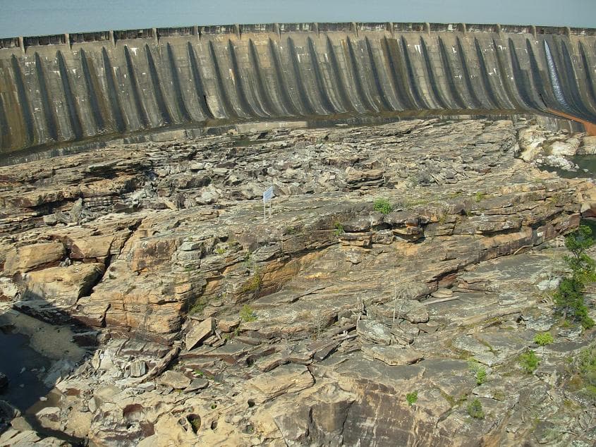
Thurlow Lake Alabama fishing: shoal bass on the smallest Tallapoosa impoundment
Alabama Power's run-of-river Thurlow Dam closed December 31, 1930 — the 574-acre pool just downstream of Yates Dam in Tallassee is prime shoal bass and spotted bass water on the lower Tallapoosa.
Thurlow Lake Alabama fishing targets shoal bass and spotted bass on a compact 574-acre Tallapoosa River pool in Tallassee, the smallest and lowest of Alabama Power's three Tallapoosa chain impoundments.
Thurlow Lake is a 574-acre run-of-river Tallapoosa River impoundment in Tallassee, Alabama — the smallest and lowest of three Alabama Power hydroelectric pools on the Tallapoosa chain, placed in service December 31, 1930. The dam was named for Oscar G. Thurlow, chief engineer and vice president of Alabama Power, who received the Franklin Institute's Howard N. Potts Medal in 1928 and invented the Thurlow Backwater Suppressor first installed at Mitchell Dam. The dam site was a 19th-century textile mill converted to a Civil War uniform and ammunition plant. As a run-of-river project, Thurlow discharges essentially the same volume it receives from Yates Dam above, holding a consistent year-round level. The Tallapoosa chain carries one of Alabama's strongest wild shoal bass fisheries — current breaks, rocky structure, and the river-channel habitat the species requires run through Yates and into Thurlow. Spotted bass mix with shoal bass throughout the 574-acre pool.
“Thurlow Lake holds fish in patterns you can set your watch to. The bite isn't a secret — it's what most fishermen don't know about where the grass thins onto a hard ledge.”
Alabama Fishing Atlas Editorial
Fishing Thurlow Lake on video
Thurlow Dam Tallassee Al. in 4k
Local aerial footage
02 · Bite Windows
Solunar Forecast
Major and minor solunar windows shift daily with the moon’s transit. Fish the windows above, or check the Seasonal Playbook below for Thurlow Lake’s current pattern.
03 · The Calendar
Seasonal Playbook
March through May is the prime window on Thurlow Lake. As water temps climb from the upper 50s through the 60s, shoal bass and spotted bass move to current-washed rocky points and gravel-bar edges at the mouths of creek pockets — inline spinners, small swimbaits, and jerkbaits on long pauses get bit on the upper lake near the Yates Dam tailwater and on the rocky Tallapoosa County shoreline. Pre-spawn fish in February and early March hold on the first rocky transitions inside the main river channel at 6 to 12 feet; a suspending jerkbait on a long pause is the go-to. When surface temps hit the low 60s in late March and April, largemouth push to the backs of the Elmore County creek pockets to spawn — wacky-rigged Senkos and chatterbaits cover the flat. Shoal bass spawn later than largemouth, typically in May on the same rocky current-break areas they hold all season. By late May, post-spawn fish slide back to main-channel structure and current seams.
June through August on Thurlow splits early-morning current fishing and midday deep structure. First light through about nine AM is the best window for surface-feeding shoal bass on current seams near the Yates Dam tailwater — topwater poppers and walking baits on rocky points produce fish before the heat builds. After the sun rises, spotted and shoal bass slide to current-broken rock in 10 to 20 feet on the main Tallapoosa channel; a ned rig, drop-shot finesse worm, and Carolina rig on gravel-bar transitions pick off the fish that pleasure-boat traffic idles past. Catfish run the main river channel at night, especially anywhere the current pushes into a soft-bottom bend. Largemouth hold on shaded wood in the creek pockets on the Elmore County side — swim jig on dock shade and flipping a jig into visible timber are the summer largemouth patterns. The Thurlow Dam tailrace concentrates catfish and spotted bass on generation current through the hottest months.
September into November is the shad-school season on Thurlow Lake. As surface temps drop from the low 80s through the 60s, baitfish push into creek mouths and along the main Tallapoosa channel, and shoal bass and spotted bass school hard on them. The upper lake near the Yates Dam tailwater and the main-channel gravel bars produce schooling fish breaking on shad — a walking topwater, fluke, or small swimbait thrown into the bust puts multiple fish in the boat. Lipless crankbaits and ChatterBaits in shad color run the staging points all day from late September through October. By late October, water temps drop into the 60s and shad school near the Thurlow Dam tailrace — a lipless crank slow-rolled along rocky transitions and a finesse jig on current-break rock produce the best fall catches. Timber and shoreline wood on the lower lake near the historic mill site also concentrate fall fish as baitfish push shallower.
December through February, surface temps drop into the 40s and 50s and the Tallapoosa River current dominates the pattern. Shoal bass and spotted bass stack on 12-to-25-foot rocky main-channel transitions between the Yates Dam tailwater and the mid-lake pool — a finesse football jig dragged on the bottom, a drop-shot fluorocarbon worm on the current break, and a blade bait fished vertically on the deepest rock transitions all produce cold-water Tallapoosa chain bass. The Thurlow Dam face concentrates baitfish and the largest catfish in the system on generation current — a heavy jig and live shad on the tailrace are the winter catfish patterns below the dam. Largemouth slide into the quiet-water wood in the creek pockets and hold tight to the deepest structure available; a slow-rolled spinnerbait and a jig-and-craw on the first warm afternoon of a cold front get the best bites. February pre-spawn fish begin showing on the first rocky points inside the main river channel as water temps recover toward the mid-50s.
12-month calendar
Tap any month to expand pattern notes. Legend: B = Bass · C = Crappie · S = Striper · Cf = Catfish.
Per-season technique videos
Kayaking the Tallapoosa below Thurlow Dam in Tallassee AL at low water
Tallapoosa paddler footage
Kayaking Below Thurlow Dam On The Tallapoosa River at 5000 cfs
Tournament pros have been decoding Thurlow Lake for five decades. Every tip on this card is cited to the original weigh-in recap or angler interview — no paraphrased fluff, no invented quotes.
2026 · spring
Alabama Power Shorelines — Thurlow operations record
Thurlow Lake reservoir and dam facts page
Thurlow dam was built as the site of an early 19th-century textile mill that was used during the Civil War as a uniform and ammunition plant. The dam was named in honor of Oscar G. Thurlow, a chief engineer, vice president and director of Alabama Power Company. Area: 574 acres. In service: 12/31/1930.
The pattern: At 574 acres Thurlow is intimate — you can cover it in a day. Plan two anchors: the Yates Dam tailwater at the top and the Thurlow Dam tailrace at the bottom. Between those two current zones, every shoal bass and spotted bass in the lake will be holding on current-break rock within casting range. A morning run from the Yates tailwater down the east-bank rocky shoreline to the mid-lake gravel bars covers the three highest-percentage areas before most boats launch.
2026 · summer
Alabama Power Shorelines — run-of-river operating note
Tallapoosa run-of-river project explanation
Yates and Thurlow lakes on the Tallapoosa River... are called 'run-of-river' projects that discharge essentially the same amount of water that flows into them. This type of operation gives them a fairly consistent lake level year round.
The pattern: Consistent level means consistent structure — the rocky bottom and gravel bars that shoal bass need are in the same place every season. Unlike storage lakes that fluctuate several feet, Thurlow stays put, so the productive areas you find in spring will fish the same in fall. The variable is current: when Yates Dam runs generators above, current pushes through the Thurlow pool and the bite shifts to the top of the lake near the tailwater. Pull up the Alabama Power Shorelines app generation schedule before you launch and plan your morning accordingly.
2025 · fall
Wikipedia — Tallassee, Alabama article
Tallassee city record and Tallapoosa chain history
The Alabama Power Company began to develop the Tallapoosa River in 1923 and in the following ten years three power plants built by the Alabama Power Company were built along the Tallapoosa River. Composed of the Thurlow Dam, the Yates Dam, and Martin Dam, these power plants have a combined capacity of 269,000 horsepower.
The pattern: Thurlow is the tail end of the Tallapoosa chain. When Lake Martin (the storage pool at the top) draws down in fall, the resulting generation flow from Martin pushes through Yates and into Thurlow — current events at the top of the chain ripple all the way down to Thurlow's doorstep. In fall, a heavy generation event from Martin and Yates can turn the upper Thurlow pool into fast-water shoal-bass habitat for the duration of the pulse. Check all three generation schedules on the Alabama Power Shorelines app the evening before you go.
Kayaking the Tallapoosa below Thurlow Dam in Tallassee AL at low water
Source: YouTube, Tallapoosa paddler footage
Around the lake
Kayaking Below Thurlow Dam On The Tallapoosa River at 5000 cfs
Source: YouTube, Tallapoosa paddler footage
06 · Planning the Trip
Stay & Eat
Where to Stay on Thurlow Lake
Lodging near the ramps. Some links below are affiliate partnerships (Booking.com, VRBO) — they cost you nothing extra and help keep the Atlas free. Full disclosure →
Best Western Alexander City
hotel
175 Aliant Parkway, Alexander City, AL 35010
Budget chain hotel in Alexander City — ~25 minutes north of Thurlow Lake via AL-22. Closest consistent lodging pool to the upper Tallapoosa chain for anglers fishing Thurlow, Yates, and Lake Martin in sequence.
Wind Creek State Park (cottages + lakeside lodging)
state park-lodge
4325 Alabama Highway 128, Alexander City, AL 35010
Alabama state park on Lake Martin ~30 minutes from Thurlow — modern cabins, lakefront primitive sites, store, full-service marina. Preferred base for a multi-day Tallapoosa chain trip.
4325 Alabama Highway 128, Alexander City, AL 35010
Large Alabama state park campground on Lake Martin — 626 improved sites, primitive tent sites, modern cabins. One of the largest state-park campgrounds in the Southeast and the default base for Tallapoosa chain fishing trips.
Chef Rob McDaniel's Southern-contemporary restaurant on the Russell Lands side of Lake Martin — upscale post-trip dinner, frequent James Beard recognition. Book ahead.
Kowaliga Restaurant
295 Kowaliga Marina Road, Alexander City, AL 35010
2,040-acre NPS battlefield on the Tallapoosa River commemorating the 1814 Creek War battle. Visitor center, 2.8-mile tour road, hiking. ~40 minutes from Thurlow — a half-day historical stop on the same river system.
Alabama Historical Commission park at the confluence of the Coosa and Tallapoosa Rivers — reconstructed French fort (1717), Andrew Jackson's 1814 fort, museum, campground. ~25 minutes southwest of Thurlow.
Non-profit lakeside family retreat and camp on Lake Martin — public chapel, lighthouse, and grounds open to visitors. A Lake Martin landmark worth pairing with a Thurlow/Yates fishing day.
1,445-acre Alabama state park on Lake Martin with beach, hiking trails, modern marina, swimming pool, horseback riding. Non-fishing family day while anglers work Thurlow/Yates below.
07 · Launch Day
On the Water
Boat ramps
concrete rampOpen
Thurlow Lake Public Access (Tallassee)
Tallassee
Parking
spots
Fee
Free
Alabama Power public access on Thurlow Lake in Tallassee. Run-of-river pool maintains a fairly consistent level year-round. Confirm current access conditions via Alabama Power Shorelines app before launching.
10-fish daily combined limit on largemouth, smallmouth, spotted, and redeye bass (statewide Alabama) · No statewide minimum on spotted bass; 12-inch minimum on largemouth and smallmouth. Shoal bass: verify current ADCNR regulations — shoal bass may have specific protections on the Tallapoosa system.
Crappie
30 per day · No statewide minimum on crappie
Striped/White Bass
Alabama Power run-of-river operation — lake level fluctuates with Yates Dam generation above. Tailrace zones below Thurlow Dam have posted current and safety restrictions. Generation can cause swift, turbulent water and rapidly rising levels with no warning.
Alabama fishing license required (residents and non-residents age 16+). Always verify current rules before your trip.
Thurlow Lake is the smallest of Alabama Power's three Tallapoosa River impoundments, a 574-acre run-of-river pool in Tallassee that straddles the Elmore and Tallapoosa county line. Alabama Power placed Thurlow Dam in service December 31, 1930, naming it for Oscar Thurlow, chief engineer and vice president of Alabama Power. Yates Dam sits immediately upstream and Lake Martin is the large storage reservoir at the top of the chain.
Thurlow Lake holds shoal bass, spotted bass, largemouth bass, catfish, bluegill, and redear sunfish. The Tallapoosa River chain — including Thurlow — is one of the strongest shoal bass fisheries remaining in Alabama. Current-washed rocky structure and the river-channel habitat through the lake supports both shoal bass and spotted bass throughout the season.
Spring (March through May) is the strongest window for shoal bass and spotted bass — pre-spawn fish stage on current-washed rock points and gravel bars along the main Tallapoosa channel. Fall (September through October) is the second-best window: shad schools concentrate on the creek mouths and main-channel staging points and both shoal bass and spotted bass feed hard on them until water temps drop through the 60s.
Yes — the Tallapoosa River chain supports wild shoal bass throughout, and Thurlow carries that character: current breaks, rocky bottom, and the main-river flow the species requires. The consistent run-of-river level keeps rocky structure in place year-round, and the lake sees far less pressure than larger Tallapoosa reservoirs. Spring pre-spawn and fall shad patterns are the two best shoal-bass windows.
Yes. Every angler age 16 and older needs an Alabama freshwater fishing license regardless of residency. Licenses are available online through the Alabama Department of Conservation and Natural Resources (ADCNR) at the Outdoor Alabama portal or at local tackle shops before you launch.
As a run-of-river project, Thurlow discharges essentially the same amount of water that flows in from Yates Dam above — the lake maintains a fairly consistent level year-round compared to storage lakes like Martin or Weiss. However, when Yates generates, current pushes through the Thurlow pool and fish stack on current-break structure near the upper lake and tailwaters. Watch the Alabama Power Shorelines app for generator schedules before fishing.
Fishing regulations, water conditions, and seasonal patterns change. Alabama Fishing Atlas provides informational content only. Verify all regulations with the Alabama Department of Conservation and Natural Resources before fishing, keeping any fish, or launching watercraft. We are not liable for decisions made based on information published here. Full disclaimer →
Citation
Data sources
—Alabama Power Shorelines — Thurlow lake operations page (https://apcshorelines.com/lake/thurlow/): area 574 acres, in service 12/31/1930, run-of-river Tallapoosa project
—Tallassee, Alabama — Wikipedia (https://en.wikipedia.org/wiki/Tallassee,_Alabama): 'It is home to a major hydroelectric power plant at Thurlow Dam operated by Alabama Power Company'; 'The Alabama Power Company began to develop the Tallapoosa River in 1923 and in the following ten years three power plants built by the Alabama Power Company were built along the Tallapoosa River. Composed of the Thurlow Dam, the Yates Dam, and Martin Dam'
—Wikimedia Commons — Category:Thurlow Dam (https://commons.wikimedia.org/wiki/Category:Thurlow_Dam): 8 files including ThurlowDam.JPG
—Wikimedia Commons — File:ThurlowDam.JPG (https://commons.wikimedia.org/wiki/File:ThurlowDam.JPG): CC BY-SA 3.0, author Rivers Langley (Saverivers), March 2007
—Alabama Power Shorelines — Lake Level Operations (https://apcshorelines.com/lake/thurlow/): 'Yates and Thurlow lakes on the Tallapoosa River... are called run-of-river projects that discharge essentially the same amount of water that flows into them. This type of operation gives them a fairly consistent lake level year round.'
—Alabama Department of Conservation and Natural Resources (ADCNR) — Outdoor Alabama freshwater fishing regulations (https://www.outdooralabama.com/)