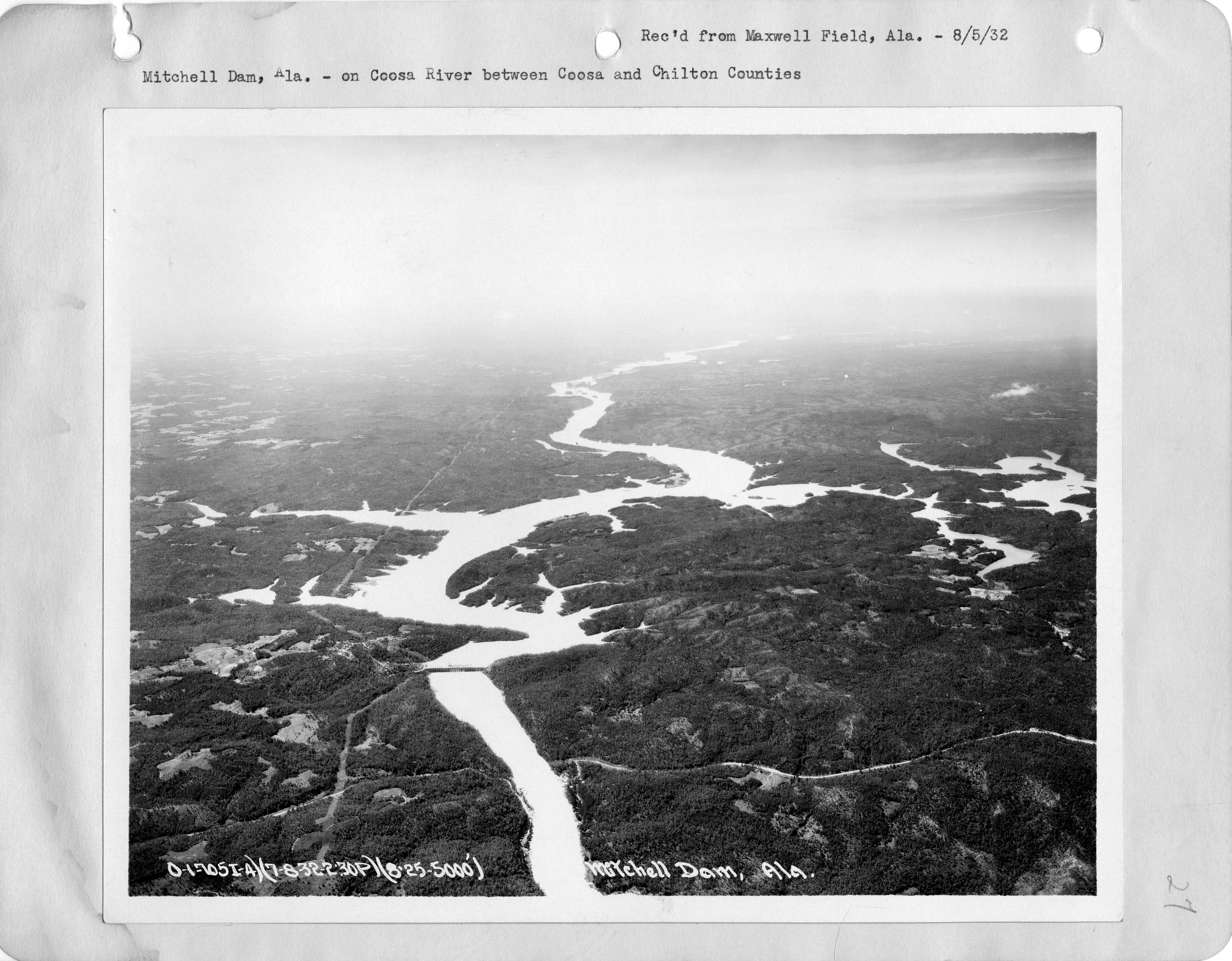
Mitchell Lake Alabama Fishing Report: 5,850 Coosa acres between Lay and Jordan
The middle link in the Coosa River chain — spotted bass country tucked between Lay Dam upstream and Jordan Dam down below, deep and clear once you clear Verbena.
Mitchell Lake Alabama fishing report: 5,850 Coosa River acres impounded by Alabama Power in 1923 between Lay Dam and Jordan Dam. Spotted bass, largemouth, and crappie work the main-river bluffs and creek arms.
Lake Mitchell is the middle link in the Coosa River chain — 5,850 acres impounded in 1923 by Alabama Power between Lay Dam upstream and Jordan Dam downstream, roughly fourteen miles of water tucked along the Chilton and Coosa county line near Verbena. The dam sits 125 feet above tailrace on the Coosa River, and the pool it holds is the quietest of the three: narrower than Lay, deeper and more river-shaped than Jordan, with long straight stretches of main-channel water that run clear once the spring runoff settles. Coosa-strain spotted bass dominate the fishery, largemouth show up in the creek arms, and crappie stack in the standing timber and brush on the mid-lake coves. The reservoir supports high densities of sport fish, and the ramps are quiet on weekdays. This fishing report covers the patterns that hold on Mitchell year round.
“Lake Mitchell holds fish in patterns you can set your watch to. The bite isn't a secret — it's what most fishermen don't know about where the grass thins onto a hard ledge.”
Alabama Fishing Atlas Editorial
Fishing Lake Mitchell on video
STRIPED BASS FISHING at Mitchell Dam (Coosa River)
Coosa striper angler
Wes Logan's Guide to the Coosa River
Wes Logan (Bassmaster Elite, Coosa native)
02 · Live
Today's Bite
—
Bite Score
Unavailable
Based on water temp, barometric pressure, moon phase & solunar window.
Major and minor solunar windows shift daily with the moon’s transit. Fish the windows above, or check the Seasonal Playbook below for Lake Mitchell’s current pattern.
03 · The Calendar
Seasonal Playbook
March through May on Lake Mitchell, the Coosa chain wakes up. Surface temperatures roll from the upper 50s into the 70s and spotted bass stage on secondary points inside Hatchet Creek, Weogufka, and Paint Creek mouths. Pre-spawn fish hold 8 to 15 feet on the first rock point inside a major creek — a suspending jerkbait on long pauses in 55°F to 62°F water moves them. The spawn runs late March through mid-April in the backs of the creek arms and on the shallow flats near Higgins Ferry. Wacky-rigged Senkos on visible beds and chatterbaits on the adjacent flats pick up cruisers. Crappie run the standing timber in Hatchet Creek hard this month — minnows on a slip cork over brush piles produce. Post-spawn shad spawn on main-lake riprap between Verbena and the dam pool triggers a first-light walking-bait window through the first week of May.
June through August, the pattern on the Coosa chain splits clean. Spotted bass slide offshore to main-river channel bluffs between Higgins Ferry and the dam — 18 to 30 feet on rock transitions and current-affected ledges — where a football jig, a drop-shot worm, and a magnum worm on a Carolina rig pick apart fish most pleasure-boat traffic idles over. Largemouth stay shallower on the upper-lake stretch below Lay Dam, holding on stump fields, shaded docks in Paint Creek, and the stump transitions in Hatchet Creek. First light to nine AM is the frog-and-buzzbait window on shallow wood; after sun-up, swim jigs and small swimbaits on dock shade keep the shallow bite working. The Mitchell Dam forebay stacks shad and the biggest summer stripers on the lake — vertical spoons when generators run. Night fishing on main-lake riprap between Verbena and the dam produces better-average fish after dark on plum-colored worms and black buzzbaits.
September through November, shad push up the Coosa River into the Mitchell creek mouths and spotted bass school up on them. The signature fall event on Mitchell is a school of Coosa-strain spotted bass breaking on shad in 10 to 18 feet off a main-lake point or inside the mouth of Hatchet Creek. Throw a walking topwater, a fluke, or a small swimbait into the bust and you can put a limit in the boat in under an hour. Weogufka and Paint Creek mouths hold the same pattern. Lipless crankbaits and ChatterBaits in shad color run the staging points all day — the fish transition from 15 to 8 feet as the water cools through the 70s into the 60s. By late October the shad spawn runs a second round on main-lake riprap, and a big topwater worked tight to the rocks on a calm October dawn produces the biggest spotted bass of the year on this lake.
December through February, Mitchell's spotted bass stack deep and concentrated. Surface temperatures drop into the 40s, main-river bluffs between Higgins Ferry and the dam forebay hold fish in 25 to 45 feet, and a football jig dragged on bluff transitions is the money bait — brown-and-purple on sunny afternoons, black-and-blue after a cold front. The Mitchell Dam forebay itself is the single densest winter concentration — shad pile against the 125-foot dam face, and a heavy spoon or blade vertically jigged along the wall produces both spots and stripers in oxygenated current when the plant runs. Lay Dam tailrace at the top of the lake is the second key winter zone — current-broken rock, shad, and warmer discharge water pull fish tight. Do not overlook a jerkbait on secondary points inside Hatchet and Weogufka during February pre-spawn warming trends — that is when the lake's biggest largemouth move first.
12-month calendar
Tap any month to expand pattern notes. Legend: B = Bass · C = Crappie · S = Striper · Cf = Catfish.
Per-season technique videos
Crushing TOPWATER Bass On Lake Mitchell!
Lake Mitchell topwater footage
January Bass Tournament on Lake Mitchell in Alabama
Tournament pros have been decoding Lake Mitchell for five decades. Every tip on this card is cited to the original weigh-in recap or angler interview — no paraphrased fluff, no invented quotes.
2025 · winter
Reed Montgomery
Reeds Guide Service — Alabama Coosa chain guide (40+ years)
Reed Montgomery has been a licensed Alabama bass fishing guide for over forty years on the Coosa chain, covering Lake Mitchell along with Lay, Logan Martin, and Jordan lakes.
The pattern: Reed's coverage confirms Mitchell is part of the working guide rotation on the Coosa — a guide who will run the middle lake when clients ask for it. Spotted bass patterns on the main-river bluffs and crappie in Hatchet Creek timber are his repeat setups on Mitchell.
2025 · winter
Alabama Power Shorelines (lake notes)
Alabama Power Shorelines — Lake Mitchell lakes info page
Lake Mitchell supports high densities of sport fish. However, swimming and boating are just as popular as fishing in warm weather thanks to plenty of docks and shoreline access.
The pattern: The Alabama Power note is useful for timing: Mitchell's sport-fish density is real, but summer weekends get pleasure-boat traffic. Weekday mornings and winter weekends are when the bluff and forebay fisheries run quiet on this lake.
reference · winter
Coosa River hydrology (Wikipedia)
Mitchell Dam specifications — Coosa River article
Mitchell Dam on the Coosa River. The dam is 125 ft high.
The pattern: The 125-foot dam is the tallest of the three lower-Coosa Alabama Power dams. That depth and the generation schedule are why the Mitchell Dam forebay is the single most concentrated winter spotted-bass pattern on the lake — deeper, colder water and stacked shad when the plant runs.
05 · Hire Local
Fishing Guides
Neutral listings — no paid placement.
Reeds Guide Service (Reed Montgomery)
Lake Mitchell, Lay Lake, Logan Martin Lake, Jordan Lake
STRIPED BASS FISHING at Mitchell Dam (Coosa River)
Source: YouTube, Coosa striper angler
Around the lake
Crushing TOPWATER Bass On Lake Mitchell!
Source: YouTube, Lake Mitchell topwater footage
06 · Planning the Trip
Stay & Eat
Where to Stay on Lake Mitchell
Lodging near the ramps. Some links below are affiliate partnerships (Booking.com, VRBO) — they cost you nothing extra and help keep the Atlas free. Full disclosure →
Inn of Clanton
hotel
946 Lake Mitchell Rd, Clanton, AL 35045
Budget-friendly independent inn on Lake Mitchell Road in Clanton — closest lodging to the Lay Dam / Mitchell Lake launches, with an attached Shoney's restaurant for early-start breakfast.
Chain hotel off I-65 exit 212 in Clanton — 15 minutes from the Mitchell Lake ramps, 25 minutes from Lay Lake. Most consistent mid-price option for traveling anglers.
Lakefront RV and cabin option on Mitchell — verify availability and current contact through the Alabama Travel portal before booking; smaller operation than chain hotels, rustic cabin style.
Full-service marina on Lake Mitchell near Verbena — boat ramp, fuel, bait, tackle, ice. Primary angler-facing marina on the Coosa pool between Lay and Jordan. Contact via alabama.travel listing before arrival; marina phone not published consistently online.
Camping
Confederate Memorial Park Campground
private
437 County Road 63, Marbury, AL 36051
Alabama Historical Commission site with a campground on the former Confederate Soldiers' Home property (1902-1939) — museum, cemetery, 102-acre grounds. Free museum admission. ~20 minutes east of Mitchell Lake.
Chilton County peach-country institution on US-31 — fresh peach ice cream, peach cobbler, country store. Mandatory summer stop for anglers driving I-65 to Mitchell.
Alabama Historical Commission site preserving the former Confederate Soldiers' Home that operated 1902-1939 — museum, cemetery, 102-acre grounds. Free admission. ~20 minutes east of Mitchell Lake.
Alabama's largest casino-resort on a Coosa River bluff ~40 minutes south of Mitchell — gaming, restaurants, RV park, entertainment. Evening destination for traveling anglers.
07 · Launch Day
On the Water
Boat ramps
concrete rampOpen
Higgins Ferry Park Boat Ramp
Clanton
Parking
spots
Fee
Chilton County fee
Chilton County park on the western shore — mid-lake access, campground and picnic area attached.
10-fish daily combined limit on largemouth, smallmouth, spotted, and redeye bass (statewide Alabama) · No statewide minimum on spotted bass; 12-inch minimum on largemouth and smallmouth (verify current ADCNR regs)
Crappie
30 per day · No statewide minimum on crappie
Striped/White Bass
Statewide limits apply — verify ADCNR Outdoor Alabama before keeping fish
Alabama Power no-wake zones in marked areas; tailrace zones below Lay Dam and Mitchell Dam have posted current and safety restrictions.
Alabama fishing license required (residents and non-residents 16+). Always verify current rules before your trip.
Late March through April is the strongest window — pre-spawn spotted bass stage on secondary points inside Hatchet, Weogufka, and Paint Creek mouths, and the spawn follows in the backs of the creeks. Fall is the second-best window: September into October, shad schools break up on main-lake points and creek mouths.
Both, but Coosa-strain spotted bass are the signature fish — hard-fighting and heavily represented on main-river bluffs, current seams, and rock transitions between Higgins Ferry and the dam. Largemouth show up best on the upper-lake stretch below Lay Dam and in Hatchet Creek timber.
Mitchell is the middle of three Alabama Power Coosa impoundments in the Clanton-Verbena stretch — Lay Dam is immediately upstream (Lay Lake above Lay Dam), Mitchell Dam is in the middle (Mitchell Lake between them), and Jordan Dam is downstream (Jordan Lake below Mitchell Dam). The pool runs about 14 miles.
Higgins Ferry Park in Chilton County is the main mid-lake ramp with campground and picnic area attached. Mitchell Dam Public Access covers the lower lake and forebay; Hatchet Creek Public Access reaches the main crappie and timber water on the Coosa County side. Lay Dam Tailrace Access covers the upper end.
Yes. All anglers over age 16 need an Alabama fishing license regardless of residency. Licenses are available online from the Alabama Department of Conservation and Natural Resources (ADCNR) or at local tackle stores before you launch.
One verified guide with both phone and website on file covers Mitchell: Reed Montgomery's Reeds Guide Service (205-663-1504, fishingalabama.com), a 40-plus-year Alabama bass guide who runs Mitchell along with Lay, Logan Martin, and Jordan. Lake Mitchell guide coverage is thinner than Lay or Guntersville — we are tracking additional verified operators.
Fishing regulations, water conditions, and seasonal patterns change. Alabama Fishing Atlas provides informational content only. Verify all regulations with the Alabama Department of Conservation and Natural Resources before fishing, keeping any fish, or launching watercraft. We are not liable for decisions made based on information published here. Full disclaimer →
Citation
Data sources
—Alabama Power Shorelines — Lake Mitchell lakes info page (https://apcshorelines.com/sl_lakes_info/lake-mitchell/)
—Wikipedia — Coosa River article, Mitchell Dam section (https://en.wikipedia.org/wiki/Coosa_River)
—Alabama Department of Conservation and Natural Resources — Reservoir Bass Fishing Reports: Lake Mitchell (https://www.outdooralabama.com/reservoir-bass-fishing-reports/lake-mitchell)
—Alabama Power — Coosa River hydroelectric system overview (Lay, Mitchell, Jordan dams)
—Reeds Guide Service (Reed Montgomery) — Alabama Coosa chain guide service (http://www.fishingalabama.com/)