Claiborne Lake Fishing: Compact Alabama River Pool
US Army Corps of Engineers Claiborne Lock & Dam built 1971 at Alabama River mile 72.5 — the southernmost Alabama River impoundment, 2,310 acres, quiet, remote, and productive for catfish and bass.
Claiborne Lake Alabama fishing covers 2,310 Alabama River acres in Monroe and Clarke counties — the southernmost and smallest of the three Alabama River impoundments, built 1971 at a 33-foot-high dam, worked for blue catfish, largemouth bass, and bream.
1971 (US Army Corps of Engineers Mobile District Claiborne Lock & Dam, Alabama River mile 72.5)
River System
Alabama River
Access
Public
01 · Overview
The Water
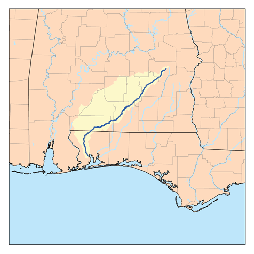
Claiborne Lake is the compact southernmost Alabama River impoundment — just 2,310 acres backed up behind the Claiborne Lock & Dam built in 1971 at Alabama River mile 72.5. The dam stands 33 feet tall and 2,550 feet long. Below Claiborne the Alabama River runs free through Clarke County to its confluence with the Tombigbee at the head of the Mobile-Tensaw Delta. Upstream sits Dannelly Reservoir (also called Millers Ferry Reservoir). Because Claiborne is small and remote — nearest town Monroeville in Monroe County, about 25 miles east of the dam — it sees relatively light angling pressure compared to the three Tombigbee pools or the Coosa-Tallapoosa chain. Blue and flathead catfish dominate the fishery; largemouth bass and crappie hold in the tributary arms and cypress-lined backwaters. The Claiborne East Bank Fishing Access below the dam is a well-known local bank-fishing spot for catfish and river species.
“Claiborne Lake holds fish in patterns you can set your watch to. The bite isn't a secret — it's what most fishermen don't know about where the grass thins onto a hard ledge.”
Alabama Fishing Atlas Editorial
Fishing Claiborne Lake on video
Alabama State Public Fishing Lakes Now Open — ADCNR
ADCNR
02 · Bite Windows
Solunar Forecast
Major and minor solunar windows shift daily with the moon’s transit. Fish the windows above, or check the Seasonal Playbook below for Claiborne Lake’s current pattern.
03 · The Calendar
Seasonal Playbook
March through May is the prime window on Claiborne Lake. Water climbs from the upper 50s into the 70s, pre-spawn largemouth stage on cypress-edge points in the Monroe County tributary arms, and a jerkbait on ten-second pauses covers the staging fish. Crappie stack on cypress stumps and brush in 6-12 feet in tributary arms — minnows and 1/16-ounce jigs produce stringers on every brush pile. Late April into May, largemouth spawn in quiet backwater pockets on both the Monroe and Clarke County sides. When USACE releases water at the upstream Millers Ferry Dam, the upper Claiborne pool fires on current-fed big blue catfish and an occasional hybrid striper. Bluegill and the occasional shellcracker move onto shallow sand-gravel flats along cypress edges for the May full-moon spawn; cricket and red worm on 3-to-6-foot flats catch stringers. Claiborne's Gulf-Coast latitude opens the spring bite a week or two earlier than Central-Alabama Tennessee River pools.
June through August Claiborne sets up on current and cypress shade. Blue catfish dominate the summer fishery — drift cut shad on the main channel bends and in the Claiborne dam forebay 20-to-33-foot water for big blues year-round. Shallow largemouth hang in the Clarke County backwater pockets on laydowns and shaded cypress — green-pumpkin tubes, wacky Senkos, frogs on sparse grass. Night fishing for big flatheads on the main Alabama River channel pulls the biggest fish of the year. First-light topwater on tributary creek mouths is the bass answer before the heat builds. Barge traffic through the lock is relatively light compared to the Tombigbee pools — Claiborne sees less tow activity because the Alabama River navigation route is a lower-volume commercial waterway. The dam tailrace on the downstream side produces catfish for bank anglers throughout summer.
September through November shad migrate out of the main Alabama River into the tributary arms and backwaters, and every species follows the bait. Largemouth chase shad on cypress-edge points, laydowns, and secondary creek-mouth structure — a lipless crankbait ripped through sparse grass, a ChatterBait in shad color, a walking bait on calm mornings over tributary creek mouths. Crappie reload on brush and timber in 8-14 feet in Monroe and Clarke County tributary arms; long-line small jigs across the cover to find the school, then fish vertical once marked. Blue cats continue on cut shad along the main channel. By mid-November the grass thins, the cooler water pushes baitfish deeper, and a slow-rolled spinnerbait becomes the late-fall largemouth answer on cypress-edge cover. Fall is the easiest season for visiting anglers to assemble a mixed-bag stringer on Claiborne.
December through February Claiborne empties out and locals who know the Alabama River channel work the deep water. Largemouth group on the Claiborne dam forebay and the deepest main-channel cypress edges — a suspending jerkbait on long pauses on sunny afternoons above 48 degrees, a hair jig vertical on the dam rock, an Alabama rig on the deepest ledges when surface temps drop into the 40s. Crappie stack on deep brush in 15-20 feet in tributary arms. Blue and flathead catfish on cut shad along the main Alabama River channel stay reliable all winter — drift-rig the 20-to-30-foot bends for the biggest cats of the year. The Claiborne dam tailrace on the downstream side stays productive for bank anglers through the cold months. Claiborne's southern latitude keeps winter water warmer than the Tennessee River chain at the same date.
12-month calendar
Tap any month to expand pattern notes. Legend: B = Bass · C = Crappie · S = Striper · Cf = Catfish.
Tournament pros have been decoding Claiborne Lake for five decades. Every tip on this card is cited to the original weigh-in recap or angler interview — no paraphrased fluff, no invented quotes.
2025 · summer
USACE Mobile District Alabama River navigation record
Claiborne Lock and Dam engineering fact sheet
The Claiborne Lock and Dam on the Alabama River was built in 1971, covers an acreage of approximately 2,310 acres of reservoir, and has a dam length of about 2,550 feet and a height of 33 feet.
The pattern: Claiborne is the smallest Alabama River pool and the closest to the Gulf. That compact footprint plus remote geography means Claiborne sees less pressure than Woodruff or Dannelly. Target the dam forebay 20-to-33-foot water for the biggest blue catfish — the deepest concentrated water point on the lake, with barge-lock-generated current fueling the bite.
2024 · fall
Alabama River Alliance angler report
Alabama River below Claiborne fishing note
The Alabama River below Claiborne Lock and Dam offers free-flowing river fishing for catfish and river bass all the way to the Mobile-Tensaw Delta confluence.
The pattern: If the Claiborne pool is not producing, cross to the downstream side. The Alabama River below Claiborne Dam is a different fishery — free-flowing river water with its own catfish and river bass population. Run downstream 10-20 miles from the dam tailrace and you are in water that fishes more like a Southern river than an impoundment.
2024
Natural Atlas Claiborne East Bank access listing
Claiborne East Bank Fishing Access profile
The Claiborne Lock and Dam East Bank Fishing Access is a designated fishing area on the Alabama River below the Claiborne Lock and Dam.
The pattern: The below-dam East Bank access is Claiborne's underrated bank-fishing asset. Free-flowing Alabama River below the 33-foot dam, rock and rip-rap, catfish and river bass. Park at the public access, walk to the rocks, fish cut shad on the bottom when USACE is running water through the gates. No boat required.
05 · Hire Local
Fishing Guides
On video
Fishing Claiborne Lake on video
On the water
Alabama State Public Fishing Lakes Now Open — ADCNR
Source: YouTube, ADCNR
06 · Planning the Trip
Stay & Eat
Where to Stay on Claiborne Lake
Lodging near the ramps. Some links below are affiliate partnerships (Booking.com, VRBO) — they cost you nothing extra and help keep the Atlas free. Full disclosure →
Holiday Inn Express Monroeville
hotel
120 Hwy 21 South, Monroeville, AL 36460
Primary chain hotel in Monroeville — about 25 minutes east of the Claiborne dam. Default Claiborne Lake angler basecamp, close to the To Kill a Mockingbird historic district.
Monroeville cafe on the historic courthouse square — Southern plates, sandwiches, association with the To Kill a Mockingbird Courthouse Museum across the street. Mandatory Monroeville lunch stop.
Museum in the Old Monroe County Courthouse made famous by Harper Lee's novel To Kill a Mockingbird — Harper Lee and Truman Capote both grew up in Monroeville. The courthouse inspired the courtroom set for the 1962 film. Mandatory family stop for Claiborne anglers.
Choctaw Bluff
scenic
Clarke County near Alabama River
Natural cliff on the lower Alabama River in Clarke County — a scenic drive viewpoint south of Claiborne Dam.
10 black bass daily aggregate (Alabama statewide) · 12-inch minimum on largemouth and smallmouth (Alabama statewide)
Crappie
30 per day · 9-inch minimum (Alabama statewide)
Striped/White Bass
Statewide temperate-bass limits apply
Claiborne Lake is a USACE Mobile District Alabama River navigation pool. Follow posted no-wake zones near the Claiborne Lock and Dam. Commercial barge traffic has right-of-way — stay off the navigation channel centerline. Generation releases from Claiborne can change water levels and current rapidly.
Alabama fishing license required for all anglers 16 and older (residents and non-residents). Always verify current rules before your trip.
Claiborne Lake is on the Alabama River in southwest Alabama, spanning Monroe and Clarke counties. The pool is impounded by the Claiborne Lock and Dam at Alabama River mile 72.5 and is the southernmost of the three Alabama River reservoirs, with Dannelly Reservoir (Millers Ferry Lake) upstream and free-flowing Alabama River below to the Mobile-Tensaw Delta.
Claiborne Lake covers 2,310 acres, making it the smallest of the three Alabama River reservoirs and one of the smaller major Alabama impoundments. The dam is 33 feet tall and 2,550 feet long at the crest.
Claiborne Lake holds blue and flathead catfish, largemouth bass, crappie, bluegill, shellcracker, and the occasional hybrid striped bass. Big blue catfish are the trophy species, concentrated in the main channel bends and the Claiborne dam forebay.
The US Army Corps of Engineers Mobile District built Claiborne Lock and Dam in 1971 at Alabama River mile 72.5. The dam provides navigation, flood control, and recreation functions for the southernmost stretch of the Alabama River above the Mobile-Tensaw Delta.
Yes, all anglers 16 and older need an Alabama fishing license regardless of residency. Purchase online at ADCNR Outdoor Alabama or at local tackle shops in Monroeville or Jackson before launching.
Fishing regulations, water conditions, and seasonal patterns change. Alabama Fishing Atlas provides informational content only. Verify all regulations with the Alabama Department of Conservation and Natural Resources before fishing, keeping any fish, or launching watercraft. We are not liable for decisions made based on information published here. Full disclaimer →
Citation
Data sources
—USACE 1974 Claiborne Lock and Dam engineering report (https://usace.contentdm.oclc.org/digital/api/collection/p16021coll7/id/15938/download)
—damsoftheworld.com Claiborne Lock and Dam (https://damsoftheworld.com/usa/alabama/claiborne-lock-and-dam): 33 ft height, 2,550 ft length, 2,310-acre pool, 1971 construction
—snoflo.org Claiborne Lock reservoir data (https://snoflo.org/reservoir/alabama/al01436-claiborne-lock)
—USACE Mobile District — Alabama River navigation pools (https://www.sam.usace.army.mil/)
—Natural Atlas Claiborne Lock East Bank Fishing Access listing
—Alabama Department of Conservation and Natural Resources Outdoor Alabama (https://www.outdooralabama.com/)